ZAC des Carmeries, plan guide, CPAUPE, fiches de lot
ZAC des Carmeries, guide plan, CPAUPE, plot specifications
MOA Métropole de Tours / Michelin · Équipe CBA (mandataire) · Mission Plan guide, fiches de lot, étude d’impact, dossier de réalisation, conseil · Rôle Chef de projet · Phase Opérationnel
MOA Métropole de Tours / Michelin · Team CBA (lead) · Mission Guide plan, plot specifications, impact study, project delivery file, advisory · Role Project manager · Phase Operational
La commande
The brief
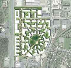
Reconversion de l’ancien site Michelin de Joué-lès-Tours en quartier mixte d’environ 200 000 m² de surface de plancher (100 000 m² tertiaires, 70 000 m² de logements, 10 à 15 000 m² de commodités). Le projet ouvre une enclave industrielle fermée sur l’est de la ville et la relie, par une passerelle au-dessus du périphérique, au parc des Bretonnières, restitué à Joué-lès-Tours.
Redevelopment of the former Michelin site in Joué-lès-Tours into a mixed-use district of roughly 200,000 m² of floor area (100,000 m² of office space, 70,000 m² of housing, 10,000-15,000 m² of amenities). The project opens up an industrial enclave closed off on the east side of the city and connects it, via a footbridge over the ring road, to the Parc des Bretonnières, returned to Joué-lès-Tours.
Enjeux
Challenges
- Faire d’une enclave industrielle une pièce urbaine ouverte, à l’interface du centre-ville et d’un grand parc métropolitain
- Tenir une centralité programmatique lisible sans renier la diversité des échelles (mail, place, venelles, cœurs d’îlot)
- Inverser la hiérarchie des mobilités : piéton et vélo d’abord, voiture ensuite
- Turning an industrial enclave into an open urban piece, at the interface between downtown and a major metropolitan park
- Maintaining a legible programmatic centrality without sacrificing a diversity of scales (mall, square, lanes, block interiors)
- Reversing the mobility hierarchy: pedestrians and cyclists first, cars second
Arbitrages
Trade-offs
La structure repose sur un parc central qui irrigue le quartier et se prolonge vers les Bretonnières. Les îlots sont conçus comme des blocs perméables dans une trame paysagère continue, avec des rez-de-chaussée actifs et des plateaux flexibles pour anticiper les reconversions d’usage. La mission couvre toute la chaîne ZAC, du plan guide aux pièces réglementaires.
The structure relies on a central park that runs through the district and extends toward the Bretonnières. The blocks are designed as permeable forms within a continuous landscaped framework, with active ground floors and flexible floor plates to anticipate future changes of use. The mission covers the full ZAC chain, from the guide plan to the regulatory documents.
Résultat & retour
Outcome & feedback
Plan guide livré en mai 2024 (indice C), projet opérationnel. Cas d’école d’une MOA mixte, entre foncier public et privé : la mission tient la cohérence entre l’ambition métropolitaine (centralité, mobilités, parc) et la temporalité d’un propriétaire industriel qui valorise son terrain. Compétence directement transposable aux missions de MOA publique sur fonciers reconvertis.
Guide plan delivered in May 2024 (revision C), project now operational. A textbook case of a mixed MOA, between public and private landholding: the mission holds together the metropolitan ambition (centrality, mobility, park) and the timeline of an industrial landowner monetizing its land. A skill set directly transferable to public MOA assignments on redeveloped land.

